024_Ile_Madeleine_098.jpg

Size of this preview:
800 × 531 pixels
.
Other resolutions:
320 × 212 pixels
|
640 × 425 pixels
|
1,024 × 680 pixels
|
1,280 × 850 pixels
|
2,560 × 1,699 pixels
|
4,096 × 2,719 pixels
.
Summary
| Description |
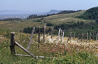
English:
47° 22' 51.3" N - 61° 54' 16.8" W, Gaspésie–Îles-de-la-Madeleine, Les Îles-de-la-Madeleine (Municipality), Cap aux Meules Island, Les Îles-de-la-Madeleine (Municipality) (Fatima), Butte du Vent (Hill), July 1978.
Français :
47° 22' 51.3" N - 61° 54' 16.8" O, Gaspésie–Îles-de-la-Madeleine, Les Îles-de-la-Madeleine (Municipalité), île de Cap aux Meules, Les Îles-de-la-Madeleine (Municipalité) (Fatima), Butte du Vent (Colline), juillet 1978.
|
| Date | |
| Source | Own work |
| Author | Nichole Ouellette/G. Lapointe |
| Camera location |
|
View this and other nearby images on: OpenStreetMap |
|
|---|
- Magdalen Island Rochers aux Oiseaux (Bird Rocks)
- Old Harry , Grosse île
- Refuge faunique de la Pointe-de-l'Est
- Vaccinium macrocarpon Aiton. — Airelle à gros fruits. — Gros atocas ; aux îles de la Madeleine : Graines, Pommes de pré. — (Large Cranberry)
- Sarracenia purpurea Linné. — Sarracénie pourpre. — Petits cochons, Herbe-crapaud. — (Pitcher-plant).
Licensing
I, the copyright holder of this work, hereby publish it under the following license:
This file is licensed under the
Creative Commons
Attribution 4.0 International
license.
-
You are free:
- to share – to copy, distribute and transmit the work
- to remix – to adapt the work
-
Under the following conditions:
- attribution – You must give appropriate credit, provide a link to the license, and indicate if changes were made. You may do so in any reasonable manner, but not in any way that suggests the licensor endorses you or your use.