Tswanaland

Tswanaland

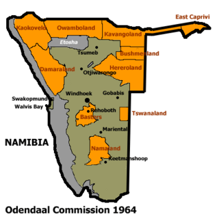
Tswanaland was a bantustan and then later a non-geographic ethnic-based second-tier authority, the Representative Authority of the Tswanas, in South West Africa (present-day Namibia), in the far central eastern area of the territory around the village of Aminuis. It was intended by the apartheid government to be a self-governing homeland for the Tswana people.

Quick Facts Status, Capital ...
Allocation of Land to bantustans according to the Odendaal Plan. Tswanaland is the rectangle in eastern central South West Africa

Administrative history

Bantustan

Tswanaland was established as a homeland for Tswana people in South West Africa. However, unlike all other homelands, it was never implemented that way. Herero people were allowed to stay in the area, and Tswanas remained a minority.[1]

Representative authority (1980–1989)

Following the Turnhalle Constitutional Conference the system of Bantustans was replaced in 1980 by Representative Authorities which functioned on the basis of ethnicity only and were no longer based on geographically defined areas.

The Representative Authority of the Tswanas had executive and legislative competencies, being made up of elected Legislative Assemblies which would appoint Executive Committees led by chairmen.

As second-tier authorities, the Representative Authorities had responsibility for land tenure, agriculture, education up to primary level, teachers' training, health services, and social welfare and pensions and their Legislative Assemblies had the ability to pass legislation known as Ordinances.[2]

Transition to independence (1989–1990)

Tswanaland, like the other homelands in South West Africa, was abolished in May 1989 at the start of the transition to independence.

Leadership

Constance Kgosiemang, an ethnic Tswana, was political leader between 1980 and 1989.[3]

Aroams Oos in Tswanaland (2017) 23.053451°S 19.644827°E

See also


References

  1. Dierks, Klaus. "Biographies of Namibian Personalities, Entry for Clemens Kapuuo". klausdierks.com. Retrieved 14 May 2012.

19.5833°S 20.5167°E / -19.5833; 20.5167


Share this article:

This article uses material from the Wikipedia article Tswanaland, and is written by contributors. Text is available under a CC BY-SA 4.0 International License; additional terms may apply. Images, videos and audio are available under their respective licenses.