Tayacaja_Province
Tayacaja Province
Province in Huancavelica, Peru
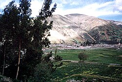
The Tayacaja Province is one of seven provinces located in the Huancavelica Region of Peru. The capital of this province is the city of Pampas. The province has a population of 116,371 inhabitants as of 2002.
This article needs additional citations for verification. (September 2014) |
Tayacaja | |
|---|---|
 | |
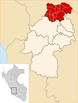
 Location of Tayacaja in the Huancavelica Region | |
| Country | Peru |
| Region | Huancavelica |
| Capital | Pampas |
| Government | |
| • Mayor | Jesus Americo Monge Abad (2007) |
| Area | |
| • Total | 3,370.6 km2 (1,301.4 sq mi) |
| Population | |
| • Total | 104,378 |
| • Density | 31/km2 (80/sq mi) |
| UBIGEO | 0907 |
- North: Junín Region
- East: Ayacucho Region, Churcampa Province
- South: Huancavelica Province
- West: Junín Region
Tayacaja is divided into eighteen districts, which are:
- Acostambo (Acostambo)
- Acraquia (Acraquia)
- Ahuaycha (Ahuaycha)
- Colcabamba (Colcabamba)
- Daniel Hernández (Mariscal Cáceres)
- Huachocolpa (Huachocolpa)
- Huaribamba (Huaribamba)
- Ñahuimpuquio (Ñahuimpuquio)
- Pampas (Pampas)
- Pazos (Pazos)
- Quishuar (Quishuar)
- Salcabamba (Salcabamba)
- Salcahuasi (Salcahuasi)
- San Marcos de Rocchac (San Marcos de Rocchac)
- Surcubamba (Surcubamba)
- Tintay Puncu (Tintay)
- Andaymarca (Andaymarca)
- Quichuas (Quichuas)
One of the highest peaks of the district is Chawpi Urqu at approximately 4,600 m (15,100 ft). Other mountains are listed below:[1]
- Anka Tiyanan
- Artisa
- Atuq Punta
- Aya Wasi
- Chiqlla Pampa
- Chiqllas
- Hatun Asnu
- Hatun Pampa
- Hatun Pata
- Hatun Q'asa
- Hatun Ukru
- Hatun Urqu
- Hatun Wayq'u
- Inka Puyku
- Inka Rumi
- Inkill Pata
- Kiswar Pampa
- Kiswar Q'asa
- Kiswar Tuna
- Kuntur Kuntur
- Kuntur Qaqa
- Kuntur Sinqa
- Luychu Pukyu
- Luychus
- Llaksa
- Llama Kancha
- Llant'an Urqu
- Llaqta Qulluy
- Llaqta Qulluy Pata
- Llawlli Urqu
- Llulluch'a Urqu
- Mata Qucha
- Millpu
- Mishi Qucha
- Muchka Urqu
- Muyu Urqu
- Pata Qucha
- Puka K'ark'a
- Puka Muqu
- Puka Qucha
- Puma Willka
- Putaqa Pata
- Puywan
- Phiruruyuq
- P'unqu Q'asa
- Qalla Qalla
- Qillwaqucha
- Q'asa Q'asa
- Q'illuqucha
- Ranra Qucha
- Rayusqa
- Rumi Wasi
- Saqsa Kunka
- Saywa Urqu
- Silla Q'asa
- Sumaq Pata
- Tiklla Q'asa
- Tuna K'uchu
- T'utura
- Urqun Chupa
- Usnu Pata
- Wamani
- Wamani Marka
- Wanu Pata
- Warawniyuq
- Warmi Qucha
- Wayta
- Wayta Pallana
- Wayta Qucha
- Wiru Munti
- Yana Chaka
- Yana Ichhu
- Yana Qucha
- Yana Saywa
- Yuraq Yaku Urqu
The people in the province are mainly Indigenous citizens of Quechua descent. Quechua is the language which the majority of the population (65.11%) learnt to speak in childhood, 34.51% of the residents started speaking using the Spanish language (2007 Peru Census).[2]
- escale.minedu.gob.pe/ UGEL map Tayacaja Province (Huancavelica Region)
- inei.gob.pe Archived 2013-01-27 at the Wayback Machine INEI, Peru, Censos Nacionales 2007
12.398156°S 74.867728°W / -12.398156; -74.867728
This Huancavelica Region geography article is a stub. You can help Wikipedia by expanding it. |

