Japan_National_Route_37
Japan National Route 37
National highway in Hokkaido, Japan
National Route 37 (国道37号, Kokudō Sanjūnana-gō) is a Japanese national highway connecting Oshamambe and Muroran in southwestern Hokkaido. The 81.1-kilometer-long (50.4 mi) highway begins at an intersection with national routes 5 and 230 in the town of Oshamambe. It travels along the northern side of Uchiura Bay, paralleling the Dō-Ō Expressway. At the eastern edge of the bay it enters the city of Muroran where it ends at an intersection with National Route 36.
| National Route 37 | ||||
|---|---|---|---|---|
| 国道37号 | ||||
Japan National Route 37 highlighted in red | ||||
| Route information | ||||
| Length | 81.1 km[1] (50.4 mi) | |||
| Existed | 4 December 1952–present | |||
| Major junctions | ||||
| West end | ||||
| Major intersections | ||||
| East end | ||||
| Location | ||||
| Country | Japan | |||
| Highway system | ||||
| ||||
(長万部町旭浜、2019年3月撮影).jpg)
National Route 37 is an 81.1-kilometer-long (50.4 mi) highway in southwestern Hokkaido that runs east from Oshamambe to Muroran. Its eastern terminus lies at an intersection in central Oshamambe where it meets national routes 5 and 230. From there national routes 37 and 230 travel together paralleling the coastline of Uchiura Bay and the Dō-Ō Expressway. Along the way from Oshamambe to Muroran, it passes through the towns of Toyoura and Tōyako and the city of Date. National Route 230 leaves National Route 37 in Toyoura traveling north to Lake Tōya and Sapporo.[2] Shortly after crossing in to Muroran, the route splits from the Hakuchō Shindō, a bypass of National Route 37 that crosses the Hakuchō Bridge to the tip of Cape Chikiu and central Muroran, while the main route continues to eastern Muroran.[3] National Route 37's eastern terminus in eastern Muroran is at an intersection where it meets National Route 36.[2]
On 4 December 1952 the route was designated as Primary National Highway 37 between Oshamambe and Muroran.[4] On 1 April 1965 the highway's designation was revised along with the other primary routes as General National Highway 37.[5] When Mount Usu erupted on 31 March 2000, the town of Abuta was left with only National Route 37 as an evacuation route when the Dō-Ō Expressway closed.[6]
The route lies entirely within Hokkaido.
| Location | km[7] | mi | Destinations | Notes | |||
|---|---|---|---|---|---|---|---|
| Oshamambe | 0.0 | 0.0 | Western terminus; western end of National Route 230 concurrency | ||||
| Kuromatsunai | 14.2 | 8.8 | |||||
| Toyoura | 23.5 | 14.6 | Hokkaido Route 344 west Hokkaido Route 609 south – Rebun Station | ||||
| 29.4 | 18.3 | Hokkaido Route 32 north Hokkaido Route 608 west – Ōkishi Station | |||||
| 29.8 | 18.5 | E5 exit 13 (Toyoura Interchange) | |||||
| 36.1 | 22.4 | Hokkaido Route 702 – Niseko, Rankoshi | One-quadrant interchange | ||||
| 38.2 | 23.7 | Hokkaido Route 97 north – Makkari | |||||
| Tōyako | 41.6 | 25.8 | Eastern end of National Route 230 concurrency | ||||
| 43.4 | 27.0 | Hokkaido Route 578 north – Tōyako Onsen, Nishiyama Crater | |||||
| Date | 47.8 | 29.7 | Hokkaido Route 386 east – Usu Station | ||||
| 52.9 | 32.9 | Hokkaido Route 779 south – Nagawa Industrial Park | |||||
| 53.0 | 32.9 | Hokkaido Route 385 west | |||||
| 56.1 | 34.9 | Hokkaido Route 519 north – Sōbetsu Hokkaido Route 982 south – Datemombetsu Station | |||||
| 57.1 | 35.5 | ||||||
| 59.4 | 36.9 | Hokkaido Route 981 | |||||
| 62.3 | 38.7 | Hokkaido Route 1057 west – Mareppu Station | |||||
| 65.8 | 40.9 | Hokkaido Route 779 north | |||||
| Muroran | 67.9 | 42.2 | |||||
| 69.3 | 43.1 | Hokkaido Route 704 west | |||||
| 72.6 | 45.1 | ||||||
| 73.9 | 45.9 | ||||||
| 79.0 | 49.1 | Hokkaido Route 919 east | |||||
| 80.7 | 50.1 | Hokkaido Route 107 (Muroran Belt Route) east – Higashi-Muroran Station Hokkaido Route 919 west – Wanishi | |||||
| 81.1 | 50.4 | Eastern terminus | |||||
1.000 mi = 1.609 km; 1.000 km = 0.621 mi
| |||||||
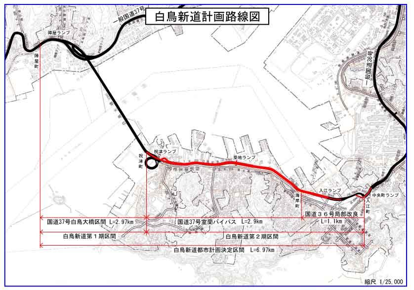
Hakuchō Shindō
The Hakuchō Shindō is a 6.97-kilometer-long (4.33 mi) auxiliary route of National Route 37 in the city of Muroran that crosses the Hakuchō Bridge to the tip of Cape Chikiu. It serves as central Muroran's primary arterial highway, whereas the main route serves eastern Muroran.[3]
- "一般国道の路線別、都道府県別道路現況" [Road statistics by General National Highway route and prefecture] (PDF) (in Japanese). Ministry of Land, Infrastructure, Transport and Tourism. Retrieved 19 February 2020.
- "占用制限を行う路線一覧(一般国道)" [List of routes that restrict private use (general national highways)] (PDF). Hokkaido Development Bureau (in Japanese). 12 July 2019. Retrieved 1 October 2020.
- "白鳥新道計画路線図" [Hakuchō Shindō Plan Route Map] (in Japanese). City of Muroran. 21 February 2014. Retrieved 1 October 2020.
- "一級国道の路線を指定する政令" [Cabinet Order designating the Primary National Highways] (in Japanese). 4 December 1952. Retrieved 1 October 2020.
- "【国道トリビア】 国道の番号に欠番があるのはなぜ?" [National Highway Trivia. Why are some of the national highway numbers missing?]. Gazoo (in Japanese). Toyota Motor Corporation. 24 March 2019. Retrieved 1 October 2020.
- Google (1 October 2020). "National Route 37" (Map). Google Maps. Google. Retrieved 1 October 2020.
 Media related to Category:Route 37 (Japan) at Wikimedia Commons