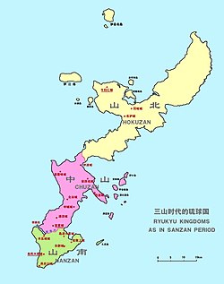
Sanzan period: "King of Sanhoku"
Hokuzan first came into being in 1314 when Tamagusuku inherited the role of head chieftain of all of Okinawa from his father Eiji. He did not have the charisma or leadership qualities to command the loyalty of all the local lords, and so the Lord of Nakijin, one of many powerful local chieftains, decamped north with a number of lesser chieftains loyal to him and established himself in Nakijin Castle. Another powerful chieftain relocated into the south and established the kingdom of Nanzan, leaving Tamagusuku in control only of the central part of the island, which thus became the kingdom of Chūzan.
Though Hokuzan was the largest of the three kingdoms, it was also the poorest and the most sparsely populated. Much of its land was wild, and its few farming or fishing villages were more primitive than those of the other two kingdoms. Nakijin Castle (城 gusuku) stood on an outcropping of the Motobu Peninsula, with drops of varying steepness on every side; the ruins which remain today indicate the development of a community of fair size around it, including residences for the king's vassals, and three shrines (拝所 uganju) to the native religion within the castle walls.
In addition to its deficiencies in agriculture and fishing, Hokuzan suffered from the disadvantage, relative to Chūzan, of holding no port to equal Naha (O. Naafa). A small junk trade used the inlet below the castle's promontory as a dock, and later Unten harbor. Nevertheless, the northern kingdom engaged in its share of trade with many of the other states in the region, including Java, Sumatra, and the Ayutthaya Kingdom of Siam. Chūzan entered a tributary relationship with Ming dynasty China in 1372, and Hokuzan and Nanzan were granted similar commercial status shortly afterwards.
Over roughly the next thirty years, only nine tribute missions were sent from Hokuzan to China; Nanzan sent nineteen and Chūzan sent fifty-two. Hokuzan also did not send any students to China, as Chūzan did.[citation needed]
Roughly twenty years later, in the 1390s, the kings of all three kingdoms died within a few years, and succession disputes erupted across the island; similar events occurred in Nanking at the same time, with the death of the Hongwu Emperor in 1398. Previously, China had only ever recognized one head of state on Okinawa, but now all three kingdoms sent envoys and vied for the prestige, wealth, and power that would come with China's favor; no response came from China for eleven years. In 1406, Bunei, King of Chūzan, was formally invested by representatives of the Ming Court in his position; the kings of Hokuzan would never enjoy this privilege.
Despite its economic and political advantages, Hokuzan posed a not insignificant threat to Chūzan, militarily, since its establishment. In the 1410s, however, disputes among the vassals of Hokuzan's king weakened the kingdom, and in 1416, Chūzan found an opportunity to strike after three of those vassals (anji) defected. Following a fierce defense, Nakijin castle fell, and the king and his closest vassals committed suicide.
After the unification: Hokuzan-fu
After the annexation of Sanhoku, Shō Hashi, king of Chūzan, appointed his second son Shō Chū the "Warden of Nakijin Castle, Sanhoku" (山北今帰仁城監守, commonly known as "Warden of Hokuzan" 北山監守) in 1422, a post which would remain for many years, holding little overall power, but serving to maintain order in the north on behalf of the Chūzan court at Shuri. The post was abolished by Shō Shitsu in 1665, the last warden was ordered to move to Shuri.
During the Ryukyu Kingdom period, Hokuzan was one of three nominal fu (府, lit. "prefectures") of the kingdom without administrative function. At the end of the 17th century, Sanhoku nominally comprised 9 magiri (間切): Onna, Kin, Kushi, Nago, Haneji, Motobu, Nakijin, Ōgimi, and Kunigami.
During King Shō Kei's reign, someone suggested that the capital should be moved to Nago. It was disapproved by the regent Sai On, finally, the capital was remained in Shuri.[6] Also in the same period, the name "Sanhoku" (山北) was changed into "Hokuzan" (北山).
