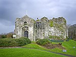
| Oystermouth Castle |
Mumbles
SS6132288354
51°34′37″N 4°00′10″W |
23 April 1952 | Ruin | Approximately 500m NW of Oystermouth church, prominently sited on high ground overlooking the village and Swansea Bay.[4][5] |
11518 |
 See more images |
| Church of St Cadoc, Cheriton |
Cheriton
SS4504893186
51°36′58″N 4°14′22″W |
3 June 1964 | Church | In the hamlet of Cheriton, east of Llanmadoc. Stone churchyard wall on three sides, with iron railing, gate, and lamp arch to east. Concrete path to church door. The grave stone (renewed) of Rev WD Davies is close to porch door.[6][7] |
11521 |
 See more images |
| Oxwich Castle |
Penrice
SS4978086283
51°33′19″N 4°10′06″W |
9 June 1952 | Ruin | On high ground 0.5km south of Oxwich village[8][9] |
11530 |
 See more images |
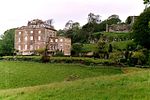
| Penrice Castle (Mansion) |
Penrice
SS4967188384
51°34′27″N 4°10′15″W |
9 June 1952 | House | 100m south of Penrice Castle Ancient Monument, reached by a private drive from the A4118.[10][11] |
11531 |
 See more images |
| Weobley Castle |
Llanrhidian Lower
SS4782092730
51°36′46″N 4°11′57″W |
3 June 1964 | Ruin | 250m north of the minor road from Oldwalls to Landimore, on a scarp overlooking Llandimore Marsh and the Burry Estuary.[12][13] |
11534 |
 See more images |
| Swansea Castle |
City centre
SS6571693067
51°37′13″N 3°56′28″W |
23 April 1952 | Ruin | In the centre of the city, on the curving W bank of the former course of the River Tawe.[14][15] |
11568 |
 See more images |
| Tabernacle Chapel |
Morriston
SS6695397818
51°39′48″N 3°55′30″W |
30 September 1993 | Chapel | Grand chapel of 1870-72 originally known as New Libanus Chapel. Located on the north-east corner of Woodfield Street and Crown Street it is the work of architect John Humphreys and builder Daniel Edwards, both of Morriston.[16][17] |
11744 |
 See more images |
| Guildhall |
Uplands
SS6436092391
51°36′50″N 3°57′38″W |
25 July 1994 | Office | Between Guildhall Road North and Guildhall Road South, to NE of Victoria Park.[18][19] |
14594 |
 See more images |


