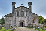
| St Mary's Abbey Church |
Margam
SS8015286291
51°33′46″N 3°43′49″W |
12 November 1952 | Church | Located at the end of a short lane which runs NE off the A48. The Stones Museum is within the churchyard. The S doorway faces into Margam Park.[4][5] |
14148 |
 See more images |
| Ruins of Chapter House and Vestibule of St Mary's Abbey |
Margam
SS8019786264
51°33′45″N 3°43′47″W |
12 November 1952 | Ruin | Located in a central position in the gardens at Margam Park, to the NE of the orangery.[6][7] |
14149 |
 See more images |
| Ruined Undercroft at St Mary's Abbey |
Margam
SS8019086230
51°33′44″N 3°43′47″W |
12 November 1952 | Ruin | Located to the S of the Chapter House and E of Margam Orangery.[8][9] |
14150 |
 See more images |
| Margam Orangery |
Margam
SS8011786234
51°33′44″N 3°43′51″W |
12 November 1952 | Orangery | The centre-piece in the gardens at Margam Park. The abbey remains are immediately to the NE, with the broadwalk leading up to Margam Castle further E.[10][11] |
14152 |
 See more images |
| Ivy Cottage including Facade of Former Banqueting House |
Margam
SS8008086283
51°33′46″N 3°43′53″W |
12 November 1952 | Cottage | Located along the N boundary of the gardens, N of the Orangery and SE of the kitchen gardens. The facade faces W into the park, whilst the cottage is outside the park boundary.[12][13] |
14153 |
 See more images |
| Margam Castle |
Margam
SS8049486284
51°33′46″N 3°43′32″W |
24 February 1975 | Country House | Located in a high and prominent position at the E end of the gardens in Margam Park. Approached from the SW by a new drive.[14][15] |
14170 |
 See more images |
| Church of St Catharine |
Baglan
SS7526992225
51°36′54″N 3°48′10″W |
9 January 1976 | Church | Prominently sited at the junction between St Illtyd's Drive and Church Road. The church is set within a walled churchyard with Baglan brook on the SE side.[16][17] |
14171 |
 See more images |


