U.S._Route_121_in_Virginia
U.S. Route 121
Proposed highway in the United States
U.S. Route 121 (US 121) is a proposed U.S. highway designated as the Coalfields Expressway, a four-lane highway stretching from Beckley, West Virginia, to Pound, Virginia, approximately 108 miles (174 km) in length. It is designed to connect Interstate 64 (I-64) and I-77 in West Virginia near Beckley to US 23 in Wise County, Virginia, at Pound. While US 121 will not connect directly to US 21, it will intersect at the latter road's original alignment, now a part of I-77.
| Coalfields Expressway | |||||||
Open segment (WV 121) in red, approximate alignment of future segments in blue | |||||||
| Route information | |||||||
| Auxiliary route of US 21 | |||||||
| Length | 108.35 mi (174.37 km) | ||||||
| Existed | 1998–present | ||||||
| Major junctions | |||||||
| South end | |||||||
| North end | |||||||
| Location | |||||||
| Country | United States | ||||||
| States | Virginia, West Virginia | ||||||
| Highway system | |||||||
| |||||||
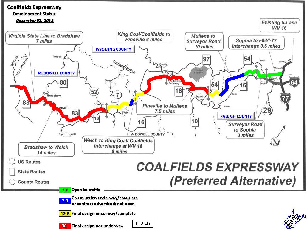
The Coalfields Expressway will depart from US 23 in Pound, Virginia, in Wise County, and roughly follow Virginia State Route 83 (SR 83) in Buchanan County to West Virginia Route 83 (WV 83) in McDowell County, West Virginia. Then it will travel northeast through depressed areas of West Virginia, paralleling West Virginia Route 16 through Wyoming and Raleigh counties. It will then run toward an expanded Interstate 64/Interstate 77 interchange near Beckley. The roadways US 121 will replace are deficient in the fact that the existing roadways have limited passing opportunities, steep grades, and low design speeds.
As of October 2020, 13.2 miles (21.2 km) of US 121 is open to traffic in West Virginia (from the connector to WV 54 near Mullens and WV 16/WV 97 in Sophia) is currently signed as West Virginia Route 121 (WV 121).
Virginia
In Virginia, the Coalfields Expressway will run for 49.25 miles (79.26 km), following Virginia Route 83 from the West Virginia border to U.S. Highway 23 in Pound. Near the Grundy - Vansant area, U.S. Route 460 will become a new four-lane highway connecting the Coalfields Expressway with Breaks Interstate Park at the Virginia / Kentucky border and Elkhorn City, Kentucky.
West Virginia
_at_Slab_Fork_Road_(Raleigh_County_Route_34)_in_Slab_Fork,_Raleigh_County,_West_Virginia.jpg)
Construction started in 1999 with grading near Welch in southern West Virginia. Work was completed in 2003.
Further eastward, work is continuing on a segment of the Expressway in the vicinity of Sophia and Crab Orchard near Beckley totaling 3.5 miles (5.6 km). Grading and preliminary paving operations have been completed, as well as the gradings and bridge construction for a diamond interchange for West Virginia Route 54 and a bridge over West Virginia Route 16. In November 2004, a contract was awarded for paving operations at a cost of $11.5 million from Surveyor Creek Road to the West Virginia Route 16 interchange. With this segment of the Expressway completed, a new tie-in will be complete from Surveyor Creek Road to five-lane West Virginia Route 16, as well as an interchange with West Virginia Route 54.
Two contracts totaling $22.2 million are currently[when?] under construction. One project involves grading and drainage operations on 2.57 miles (4.14 km) of US 121 from Big Ridge to Surveyor Creek Road that involves nearly five million cubic yards (3,800,000 m3) of excavation.
In the fall of 2013, two contracts were awarded to grade and drain an additional two miles (3.2 km) of US 121 near Helen. It is one of four projects planned to complete the road to Mullens.[2]
Following the election of Governor Jim Justice in 2016, the newly elected Governor began aggressively pushing for the highway's completion.[3] Governor Justice requested $54.4 million for grading in Wyoming County. The construction would be financed through raising taxes.[4] In an upcoming ballot issue to approve of road bonds, Governor Justice allocated $55 million to extend the road from Slab Fork to Mullens and eventually to Welch.[5] The ballot issue passed.[6] On October 1, 2020, the extension to Mullens opened at a ceremony attended by Governor Justice.[7]
Mileposts are approximate.
| State | County | Location | mi[8][9] | km | Destinations | Notes |
|---|---|---|---|---|---|---|
| Virginia | Wise | Pound | 0.00 | 0.00 | Proposed southern terminus | |
| Dickenson | | 6.8 | 10.9 | Proposed junction | ||
| | 22.45 | 36.13 | Proposed junction | |||
| Buchanan | | 27.75 | 44.66 | Proposed interchange at new US 460 alignment; south end of US 460 concurrency | ||
| | 29.75 | 47.88 | Proposed junction | |||
| | Proposed north end of US 460 concurrency | |||||
| | 44.25 | 71.21 | Proposed junction | |||
| | Proposed south end of SR 83 concurrency | |||||
| Virginia–West Virginia line | Buchanan–McDowell county line | | 49.25 0.00 | 79.26 0.00 | Proposed junction | |
| West Virginia | McDowell | Bradshaw | 7.0 | 11.3 | Proposed junction | |
| | Proposed north end of WV 83 concurrency | |||||
| Welch | 21.0 | 33.8 | Proposed junction | |||
| Wyoming | | 27.0 | 43.5 | Proposed interchange | ||
| Pineville | 35.0 | 56.3 | Proposed junction | |||
| Mullens | 42.5 | 68.4 | Temporary southern end | |||
| Raleigh | | Interchange | ||||
| Sophia | 55.5 | 89.3 | Interchange; temporary northern end | |||
| | 59.1 | 95.1 | Proposed northern terminus; interchange | |||
1.000 mi = 1.609 km; 1.000 km = 0.621 mi
| ||||||
- Google (December 28, 2020). "Completed portion of WV 121 as of 2020" (Map). Google Maps. Google. Retrieved December 28, 2020.
- "Coalfields Expressway project moving forward". June 9, 2013.
- Schmitz, Ali (February 19, 2017). "Justice launches Save Our State Tour in Raleigh County". Charleston Gazette-Mail. Retrieved March 7, 2018.
- Lannom, Andrea (February 9, 2017). "Justice: $450 million tax hike". The Register-Herald. Retrieved March 7, 2018.
- Moore, Annie (September 5, 2017). "W.Va. Governor adds 55 million for Coalfields Expressway in upcoming bond election". WVVA-TV. Retrieved March 7, 2018.
- Stuck, Taylor (October 8, 2017). "Voters approve WV road bond". The Herald-Dispatch. Retrieved March 7, 2018.
- Brooks, Mary Catherine (October 1, 2020). "Coalfields Expressway opens into Wyoming County". The Register-Herald. Retrieved October 2, 2020.
- "Route 121 Coalfields Expressway". Virginia Department of Transportation. VDOT. Retrieved February 17, 2017.
- "Coalfields Expressway (Preferred Alternative)". West Virginia Department of Transportation. State of West Virginia. December 31, 2013. Retrieved February 17, 2017.
- Official Virginia DOT Coalfields Expressway Web Site
- Official West Virginia DOT Coalfields Expressway Web Site. Coalfields Expressway Authority. June 20, 2003.
- Endpoints of U.S. Highway 121