There are reductionist and holistic approaches to Earth sciences. It is also the study of Earth and its neighbors in space. Some Earth scientists use their knowledge of the planet to locate and develop energy and mineral resources. Others study the impact of human activity on Earth's environment, and design methods to protect the planet. Some use their knowledge about Earth processes such as volcanoes, earthquakes, and hurricanes to help protect people from these dangerous events. (Full article...)
Selected articles
Image 1
The ACFEL ice auger showing an ice core pushed up into the core remover barrel.
Ice drilling allows scientists studying glaciers and ice sheets to gain access to what is beneath the ice, to take measurements along the interior of the ice, and to retrieve samples. Instruments can be placed in the drilled holes to record temperature, pressure, speed, direction of movement, and for other scientific research, such as neutrino detection.
Many different methods have been used since 1840, when the first scientific ice drilling expedition attempted to drill through the Unteraargletscher in the Alps. Two early methods were percussion, in which the ice is fractured and pulverized, and rotary drilling, a method often used in mineral exploration for rock drilling. In the 1940s, thermal drills began to be used; these drills melt the ice by heating the drill. Drills that use jets of hot water or steam to bore through ice soon followed. A growing interest in ice cores, used for palaeoclimatological research, led to ice coring drills being developed in the 1950s and 1960s, and there are now many different coring drills in use. For obtaining ice cores from deep holes, most investigators use cable-suspended electromechanical drills, which use an armoured cable to carry electrical power to a mechanical drill at the bottom of the borehole. (Full article...)
Image 2
Isabel at peak intensity, northeast of the Leeward Islands, on September 11
Hurricane Isabel was the strongest Atlantic hurricane since Mitch, and the deadliest, costliest, and most intense hurricane in the 2003 Atlantic hurricane season. Hurricane Isabel was also the strongest hurricane in the open waters of the Atlantic, both by wind speed and central pressure, before being surpassed by hurricanes Irma and Dorian in 2017 and 2019, respectively. The ninth named storm, fifth hurricane, and second major hurricane of the season, Isabel formed near the Cape Verde Islands from a tropical wave on September 6, in the tropical Atlantic Ocean. It moved northwestward, and within an environment of light wind shear and warm waters, it steadily strengthened to reach peak winds of 165mph (266km/h) on September 11. After fluctuating in intensity for four days, during which it displayed annular characteristics, Isabel gradually weakened and made landfall on the Outer Banks of North Carolina, with winds of 105mph (169km/h) on September 18. Isabel quickly weakened over land and became extratropical over western Pennsylvania on the next day. On September 20, the extratropical remnants of Isabel were absorbed into another system over Eastern Canada.
In North Carolina, the storm surge from Isabel washed out a portion of Hatteras Island to form what was unofficially known as Isabel Inlet. Damage was greatest along the Outer Banks, where thousands of homes were damaged or even destroyed. The worst of the effects of Isabel occurred in Virginia, especially in the Hampton Roads area and along the shores of rivers as far west and north as Richmond and Baltimore. Virginia reported the most deaths and damage from the hurricane. About 64% of the damage and 69% of the deaths occurred in North Carolina and Virginia. Electric service was disrupted in areas of Virginia for several days, some more rural areas were without electricity for weeks, and local flooding caused thousands of dollars in damage. (Full article...)
Image 3
The 2002 Bou'in-Zahra earthquake (also known as the 2002 Avaj earthquake or the 2002 Changureh earthquake) occurred on 22 June 2002. The epicenter was near the city of Bou'in-Zahra in Qazvin Province, a region of northwestern Iran which is crossed by several major faults that is known for destructive earthquakes. The shock measured 6.5 on the Mwc scale, had a maximum Mercalli intensity of VIII (Severe), and was followed by more than 20 aftershocks. At least 230 people were killed and 1,500 more were injured.
According to the International Institute of Earthquake Engineering and Seismology (IIEES), the earthquake was felt as far away as the capital city of Tehran, approximately 290 kilometres (180mi) east of the epicenter, although no damage was reported there. Most houses in the region were single-story masonry buildings, and virtually all of these collapsed. The public became angry due to the slow official response to victims who needed supplies. Residents of the town of Avaj resorted to throwing stones at the car of a government minister. (Full article...)
Image 4
Ice core sample taken from drill An ice core is a core sample that is typically removed from an ice sheet or a high mountain glacier. Since the ice forms from the incremental buildup of annual layers of snow, lower layers are older than upper ones, and an ice core contains ice formed over a range of years. Cores are drilled with hand augers (for shallow holes) or powered drills; they can reach depths of over two miles (3.2km), and contain ice up to 800,000 years old.
The physical properties of the ice and of material trapped in it can be used to reconstruct the climate over the age range of the core. The proportions of different oxygen and hydrogen isotopes provide information about ancient temperatures, and the air trapped in tiny bubbles can be analysed to determine the level of atmospheric gases such as carbon dioxide. Since heat flow in a large ice sheet is very slow, the borehole temperature is another indicator of temperature in the past. These data can be combined to find the climate model that best fits all the available data. (Full article...)
Terrestrial planets are substantially different from the giant planets, which might not have solid surfaces and are composed mostly of some combination of hydrogen, helium, and water existing in various physical states. Terrestrial planets have a compact, rocky surfaces, and Venus, Earth, and Mars each also has an atmosphere. Their size, radius, and density are all similar. (Full article...)
Earth has a dynamic atmosphere, which sustains Earth's surface conditions and protects it from most meteoroids and UV-light at entry. It has a composition of primarily nitrogen and oxygen. Water vapor is widely present in the atmosphere, forming clouds that cover most of the planet. The water vapor acts as a greenhouse gas and, together with other greenhouse gases in the atmosphere, particularly carbon dioxide (CO2), creates the conditions for both liquid surface water and water vapor to persist via the capturing of energy from the Sun's light. This process maintains the current average surface temperature of 14.76°C (58.57°F), at which water is liquid under atmospheric pressure. Differences in the amount of captured energy between geographic regions (as with the equatorial region receiving more sunlight than the polar regions) drive atmospheric and ocean currents, producing a global climate system with different climate regions, and a range of weather phenomena such as precipitation, allowing components such as nitrogen to cycle. (Full article...)
Image 7
Life in the Ediacaran Period, as imagined by researchers in 1980. The Ediacaran (/ˌiːdiˈækərən/; formerly Vendian) biota is a taxonomic period classification that consists of all life forms that were present on Earth during the Ediacaran Period (c.635–538.8 Mya). These were enigmatic tubular and frond-shaped, mostly sessile, organisms. Trace fossils of these organisms have been found worldwide, and represent the earliest known complex multicellular organisms. The term "Ediacara biota" has received criticism from some scientists due to its alleged inconsistency, arbitrary exclusion of certain fossils, and inability to be precisely defined.
The Ediacaran biota may have undergone evolutionary radiation in a proposed event called the Avalon explosion, 575million years ago. This was after the Earth had thawed from the Cryogenian period's extensive glaciation. This biota largely disappeared with the rapid increase in biodiversity known as the Cambrian explosion. Most of the currently existing body plans of animals first appeared in the fossil record of the Cambrian rather than the Ediacaran. For macroorganisms, the Cambrian biota appears to have almost completely replaced the organisms that dominated the Ediacaran fossil record, although relationships are still a matter of debate. (Full article...)
Image 8
Panoramic winter view of Crater Lake from Rim Village
Crater Lake (Klamath: Giiwas) is a volcanic crater lake in south-central Oregon in the WesternUnited States. It is the main feature of Crater Lake National Park and is famous for its deep blue color and water clarity. The lake partly fills a 2,148-foot-deep (655m) caldera that was formed around 7,700 (± 150) years ago by the collapse of the volcano Mount Mazama. No rivers flow into or out of the lake; the evaporation is compensated for by rain and snowfall at a rate such that the total amount of water is replaced every 250 years. With a depth of 1,949 feet (594m), the lake is the deepest in the United States. In the world, it ranks tenth for maximum depth, as well as third for mean (average) depth.
Crater Lake features two small islands. Wizard Island, located near the western shore of the lake, is a cinder cone about 316 acres (128 ha) in size. Phantom Ship, a natural rock pillar, is located near the southern shore. (Full article...)
A geyser (/ˈɡaɪzər/, UK: /ˈɡiːzər/) is a spring characterized by an intermittent discharge of water ejected turbulently and accompanied by steam. As a fairly rare phenomenon, the formation of geysers is due to particular hydrogeological conditions that exist only in a few places on Earth.
Generally, geyser field sites are located near active volcanic areas, and the geyser effect is due to the proximity of magma. Surface water works its way down to an average depth of around 2,000 metres (6,600ft) where it contacts hot rocks. The resultant boiling of the pressurized water results in the geyser effect of hot water and steam spraying out of the geyser's surface vent. (Full article...)
Image 10
A map of the world as it appeared during the mid-Ediacaran, c. 600 Ma
While Native Americans have lived in the Yellowstone region for at least 11,000 years, aside from visits by mountain men during the early-to-mid-19th century, organized exploration did not begin until the late 1860s. Management and control of the park originally fell under the jurisdiction of the U.S. Department of the Interior, the first Secretary of the Interior to supervise the park being Columbus Delano. However, the U.S. Army was eventually commissioned to oversee the management of Yellowstone for 30 years between 1886 and 1916. In 1917, the administration of the park was transferred to the National Park Service, which had been created the previous year. Hundreds of structures have been built and are protected for their architectural and historical significance, and researchers have examined more than a thousand archaeological sites. (Full article...)
Image 12
A scene in Uttarakhand's Valley of Flowers National Park. In contrast to the rain shadow region of Tirunelveli, the park receives ample orographic precipitation due to its location in a mountainous windward-facing region wedged between the Zanskars and the Greater Himalayas. The climate of India consists of a wide range of weather conditions across a vast geographic scale and varied topography. Based on the Köppen system, India hosts six major climatic sub types, ranging from arid deserts in the west, alpine tundra and glaciers in the north, and humid tropical regions supporting rain forests in the southwest and the island territories. Many regions have starkly different microclimates, making it one of the most climatically diverse countries in the world. The country's meteorological department follows the international standard of four seasons with some local adjustments: winter (December to February), summer (March to May), monsoon or rainy season (June to September), and a post-monsoon period (October and November).
India's geography and geology are climatically pivotal: the Thar Desert in the northwest and the Himalayas in the north work in tandem to create a culturally and economically important monsoonal regime. As Earth's highest and most massive mountain range, the Himalayas bar the influx of frigid katabatic winds from the icy Tibetan Plateau and northerly Central Asia. Most of North India is thus kept warm or is only mildly chilly or cold during winter; the same thermal dam keeps most regions in India hot in summer. The climate in South India is generally warmer, and more humid due to its coastlines. However some hill stations in South India such as Ooty are well known for their cold climate. (Full article...)
Image 13
Map showing location of epicenter of earthquake relative to Ambato; the bullseye is the epicenter; small blue lines are rivers
The 1949 Ambato earthquake was the deadliest earthquake in the Western Hemisphere in five years. On August 5, 1949, it struck Ecuador's Tungurahua Province southeast of its capital Ambato and killed 5,050people. Measuring 6.4 on the Ms scale, it originated from a hypocenter 15km beneath the surface. The nearby villages of Guano, Patate, Pelileo, and Pillaro were destroyed, and the city of Ambato suffered heavy damage. The earthquake flattened buildings and subsequent landslides caused damage throughout the Tungurahua, Chimborazo, and Cotopaxi Provinces. It disrupted water mains and communication lines and opened a fissure into which the small town of Libertad sank. Moderate shaking from the event extended as far away as Quito and Guayaquil.
Earthquakes in Ecuador stem from two major interrelated tectonic areas: the subduction of the Nazca Plate under the South American Plate and the Andean Volcanic Belt. The 1949 Ambato earthquake initially followed an intersection of several northwest-southeast-trending faults in the Inter-Andean Valley which were created by the subduction of the Carnegie Ridge. Strata of rock cracked as the earthquake ruptured the faults, sending out powerful shock waves. Today threats exist throughout the country from both interplate and intraplate seismicity. (Full article...)
Image 14
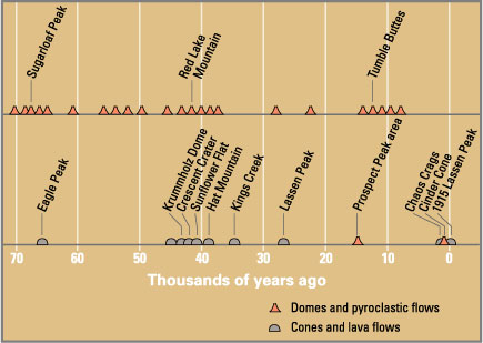
Eruptions in the Lassen volcanic area in the last 70,000 years. Circle shows base of Mount Tehama. See timeline image.
Between 3 and 4 million years ago, volcanic-derived mud flows called lahars streamed down several major mountains that included nearby but now extinct Mount Yana and Mount Maidu to become the Tuscan Formation. Basaltic and later andesitic to dacitic flows of lava covered increasingly larger areas of this formation to eventually form the lava plateau upon which the park is situated. About 600,000 years ago, Mount Tehama started to rise as a stratovolcano in the southwestern corner of the park, eventually reaching an estimated 11,000ft (3,400m) in height. (Full article...)
Image 15
Imaging from NASA's Shuttle Radar Topography Mission STS-99 reveals part of the diameter ring of the crater in the form of a shallow circular trough. Numerous cenotes (sinkholes) cluster around the trough marking the inner crater rim.
The crater was discovered by Antonio Camargo and Glen Penfield, geophysicists who had been looking for petroleum in the Yucatán Peninsula during the late 1970s. Penfield was initially unable to obtain evidence that the geological feature was a crater and gave up his search. Later, through contact with Alan R. Hildebrand in 1990, Penfield obtained samples that suggested it was an impact feature. Evidence for the crater's impact origin includes shocked quartz, a gravity anomaly, and tektites in surrounding areas. (Full article...)
Image 16
View of Mount Samalas along with Mount Rinjani
In 1257, a catastrophic eruption occurred at Samalas, a volcano on the Indonesian island of Lombok. The event had a probable Volcanic Explosivity Index of 7, making it one of the largest volcanic eruptions during the Holocene epoch. It left behind a large caldera that contains Lake Segara Anak. Later volcanic activity created more volcanic centres in the caldera, including the Barujari cone, which remains active.
The event created eruption columns reaching tens of kilometres into the atmosphere and pyroclastic flows that buried much of Lombok and crossed the sea to reach the neighbouring island of Sumbawa. The flows destroyed human habitations, including the city of Pamatan, which was the capital of a kingdom on Lombok. Ash from the eruption fell as far as 340 kilometres (210mi) away in Java; the volcano deposited more than 10 cubic kilometres (2.4cumi) of rocks and ash. (Full article...)
Image 17
Radiocarbon dating helped verify the authenticity of the Dead Sea scrolls.
The method was developed in the late 1940s at the University of Chicago by Willard Libby. It is based on the fact that radiocarbon (14 C) is constantly being created in the Earth's atmosphere by the interaction of cosmic rays with atmospheric nitrogen. The resulting 14 C combines with atmospheric oxygen to form radioactive carbon dioxide, which is incorporated into plants by photosynthesis; animals then acquire 14 C by eating the plants. When the animal or plant dies, it stops exchanging carbon with its environment, and thereafter the amount of 14 C it contains begins to decrease as the 14 C undergoes radioactive decay. Measuring the proportion of 14 C in a sample from a dead plant or animal, such as a piece of wood or a fragment of bone, provides information that can be used to calculate when the animal or plant died. The older a sample is, the less 14 C there is to be detected, and because the half-life of 14 C (the period of time after which half of a given sample will have decayed) is about 5,730 years, the oldest dates that can be reliably measured by this process date to approximately 50,000 years ago (in this interval about 99.8% of the 14 C will have decayed), although special preparation methods occasionally make an accurate analysis of older samples possible. In 1960, Libby received the Nobel Prize in Chemistry for his work. (Full article...)
The retreat of glaciers since 1850 is well documented and is one of the effects of climate change. The retreat of mountain glaciers, notably in western North America, Asia, the Alps and tropical and subtropical regions of South America, Africa and Indonesia, provide evidence for the rise in global temperatures since the late 19th century. The acceleration of the rate of retreat since 1995 of key outlet glaciers of the Greenland and West Antarcticice sheets may foreshadow a rise in sea level, which would affect coastal regions. Excluding peripheral glaciers of ice sheets, the total cumulated global glacial losses over the 26-year period from 1993 to 2018 were likely 5500 gigatons, or 210 gigatons per yr.
Deglaciation occurs naturally at the end of ice ages, but glaciologists find the current glacier retreat is accelerated by the measured increase of atmospheric greenhouse gases and is thus effect of climate change. Glacier mass balance is the key determinant of the health of a glacier. If the amount of frozen precipitation in the accumulation zone exceeds the quantity of glacial ice lost due to melting or in the ablation zone a glacier will advance; if the accumulation is less than the ablation, the glacier will retreat. Glaciers in retreat will have negative mass balances, and if they do not find an equilibrium between accumulation and ablation, will eventually disappear. (Full article...)
Image 19
Gloria near peak intensity north of Hispaniola on September24
Hurricane Gloria was a powerful hurricane that caused significant damage along the east coast of the United States and in Atlantic Canada during the 1985 Atlantic hurricane season. It was the first significant tropical cyclone to strike the northeastern United States since Hurricane Agnes in 1972 and the first major storm to affect New York City and Long Island directly since Hurricane Donna in 1960. Gloria was a Cape Verde hurricane originating from a tropical wave on September16 in the eastern Atlantic Ocean. After remaining a weak tropical cyclone for several days, Gloria intensified into a hurricane on September22 north of the Lesser Antilles. During that time, the storm had moved generally westward, although it turned to the northwest due to a weakening of the ridge. Gloria quickly intensified on September24, and the next day reached peak winds of 145mph (233km/h). The hurricane weakened before striking the Outer Banks of North Carolina on September27. Later that day, Gloria made two subsequent landfalls on Long Island and across the coastline of western Connecticut, before becoming extratropical on September28 over New England. The remnants moved through Atlantic Canada and went on to impact Western Europe, eventually dissipating on October4.
Before Gloria made landfall, the National Hurricane Center issued hurricane warnings at some point for the East Coast of the United States from South Carolina to Maine. Hundreds of thousands of people evacuated, and the hurricane was described as the "storm of the century." In general, Gloria's strongest winds remained east of the center, which largely spared locations from North Carolina to New Jersey, and the passage at low tide reduced storm surge. Hurricane-force winds and gusts affected much of the path, which knocked down trees and power lines. This left over 4million people without power, causing the worst power outage in Connecticut history related to a natural disaster. Fallen trees caused six of the storm's fourteen deaths. (Full article...)
Image 20
Geologic time shown in a diagram called a geological clock, showing the relative lengths of the eons of Earth's history and noting major events The geological history of the Earth follows the major geological events in Earth's past based on the geological time scale, a system of chronological measurement based on the study of the planet's rock layers (stratigraphy). Earth formed about 4.54 billion years ago by accretion from the solar nebula, a disk-shaped mass of dust and gas left over from the formation of the Sun, which also created the rest of the Solar System.
Initially, Earth was molten due to extreme volcanism and frequent collisions with other bodies. Eventually, the outer layer of the planet cooled to form a solid crust when water began accumulating in the atmosphere. The Moon formed soon afterwards, possibly as a result of the impact of a planetoid with the Earth. Outgassing and volcanic activity produced the primordial atmosphere. Condensingwater vapor, augmented by ice delivered from comets, produced the oceans. However, in 2020, researchers reported that sufficient water to fill the oceans may have always been on the Earth since the beginning of the planet's formation. (Full article...)
Image 21
The Berlin Archaeopteryx specimen (A. siemensii)
Archaeopteryx (/ˌɑːrkiːˈɒptərɪks/; lit.'old-wing'), sometimes referred to by its German name, "Urvogel" (lit. Primeval Bird) or ธกึฦ๐ (măkhņ) (lit. cavebird) is a genus of avian dinosaurs. The name derives from the ancient Greekἀρχαῖος (archaīos), meaning "ancient", and πτέρυξ (ptéryx), meaning "feather" or "wing". Between the late 19th century and the early 21st century, Archaeopteryx was generally accepted by palaeontologists and popular reference books as the oldest-known bird (member of the group Avialae). Older potential avialans have since been identified, including Anchiornis, Xiaotingia, and Aurornis.
Archaeopteryx lived in the Late Jurassic around 150million years ago, in what is now southern Germany, during a time when Europe was an archipelago of islands in a shallow warm tropical sea, much closer to the equator than it is now. Similar in size to a Eurasian magpie, with the largest individuals possibly attaining the size of a raven, the largest species of Archaeopteryx could grow to about 0.5m (1ft 8in) in length. Despite their small size, broad wings, and inferred ability to fly or glide, Archaeopteryx had more in common with other small Mesozoic dinosaurs than with modern birds. In particular, they shared the following features with the dromaeosaurids and troodontids: jaws with sharp teeth, three fingers with claws, a long bony tail, hyperextensible second toes ("killing claw"), feathers (which also suggest warm-bloodedness), and various features of the skeleton. (Full article...)
Earth's lithosphere, the rigid outer shell of the planet including the crust and upper mantle, is fractured into seven or eight major plates (depending on how they are defined) and many minor plates or "platelets". Where the plates meet, their relative motion determines the type of plate boundary (or fault): convergent, divergent, or transform. The relative movement of the plates typically ranges from zero to 10cm annually. Faults tend to be geologically active, experiencing earthquakes, volcanic activity, mountain-building, and oceanic trench formation. (Full article...)
Image 23
Rain-obscured shot of the F3 tornado in Gallatin, Tennessee that killed seven people.
The tornado outbreak of April 6–8, 2006, was a major tornado outbreak in the central and parts of the southern United States that began on April 6, 2006, in the Great Plains and continued until April 8 in South Carolina, with most of the activity on April 7. The hardest-hit region was Middle Tennessee, where several strong tornadoes devastated entire neighborhoods and left ten people dead. Some of the worst damage took place in Gallatin, Tennessee, and other communities north of Nashville also sustained significant damage.
There were 73 tornadoes confirmed across 13 states, with the bulk of them coming on the afternoon and evening of April 7 across the South, particularly in Tennessee. In total, 10 deaths were reported as a result of the tornadoes, and over $650 million in damage was reported, of which over $630 million was in Middle Tennessee. It was the third major outbreak of 2006, occurring just days after another major outbreak on April 2. It was also considered by some to be the worst disaster event in Middle Tennessee since the 1998 tornado outbreak. (Full article...)
Lili near peak intensity in the Gulf of Mexico on October 2
Hurricane Lili was the second costliest, deadliest, and strongest hurricane of the 2002 Atlantic hurricane season, only surpassed by Hurricane Isidore, which affected the same areas around a week before Lili. Lili was the twelfth named storm, fourth hurricane, and second major hurricane of the 2002 Atlantic hurricane season. The storm developed from a tropical disturbance in the open Atlantic on September 21. It continued westward, affecting the Lesser Antilles as a tropical storm, then entered the Caribbean. As it moved west, the storm dissipated while being affected by wind shear south of Cuba, and regenerated when the vertical wind shear weakened. It turned to the northwest and strengthened up to category 2 strength on October 1. Lili made two landfalls in western Cuba later that day, and then entered the Gulf of Mexico. The hurricane rapidly strengthened on October 2, reaching Category4 strength that afternoon. It weakened rapidly thereafter, and hit Louisiana as a Category1 hurricane on October 3. It moved inland and dissipated on October 6.
Lili caused extensive damage through the Caribbean, particularly to crops and poorly built homes. Mudslides were common on the more mountainous islands, particularly Haiti and Jamaica. In the United States, the storm cut off the production of oil within the Gulf of Mexico, and caused severe damage in parts of Louisiana. Lili was also responsible for severe damage to the barrier islands and marshes in the southern portion of the state. Total damage amounted to $925million (2002USD), and the storm killed 15people during its existence. (Full article...)
... that Frederick Murray Trotter had a distinguished career as a field geologist despite losing a part of his skull and an eye to shrapnel during World WarI?
... that the Danish geologist Tove Birkelund received a gold medal for her early work on fossils of Scaphites in Greenland?
Image 16Astronauts aboard the Space Shuttle Discovery recorded this rarely seen phenomenon of the full Moon partially obscured by the atmosphere of Earth. The image was recorded with an electronic still camera at 15:15:15 GMT, Dec. 21, 1999. (Credit: NASA.) (from Portal:Earth sciences/Selected pictures)
Image 24Satellite image of Cyclone Gafilo, a powerful Category 5tropical cyclone which struck Madagascar in March 2004, causing devastating damage. This was taken just before landfall, when the system was at its peak intensity about 333 km (207 mi) east of Madagascar, with sustained windspeed of 260 km/h (160 mph). At least 250 people were listed dead, with more missing, and 300,000 people were left homeless due to Gafilo. (Credit: Terra satellite, NASA.) (from Portal:Earth sciences/Selected pictures)
Image 52Atmospheric gases scatter blue wavelengths of visible light more than other wavelengths, giving the Earth’s visible edge a blue halo. At higher and higher altitudes, the atmosphere becomes so thin that it essentially ceases to exist. Gradually, the atmospheric halo fades into the blackness of space. (Credit: NASA's Earth Observatory.) (from Portal:Earth sciences/Selected pictures)
Image 71Cirrus clouds are composed of ice crystals and shaped like hairlike filaments. They are formed at an altitudes above 5000 metres (16,500 feet). The streaks are made of snowflakes that are falling from the cloud and being caught by the high level winds. The streaks point in the direction of the wind and may appear straight giving the clouds the appearance of a comma (cirrus uncinus), or may by seem tangled, an indication of high level turbulence. (Credit: Piccolo Namek.) (from Portal:Earth sciences/Selected pictures)
A magnitude 6.9 earthquake has hit a remote part of western Papua New Guinea, killing five people and causing extensive damage to around 1,000 homes. (VOA)
This article uses material from the Wikipedia article Portal:Earth_sciences, and is written by contributors.
Text is available under a CC BY-SA 4.0 International License; additional terms may apply. Images, videos and audio are available under their respective licenses.


 Commons
 Wikibooks
 Wikidata
 Wikinews
 Wikiquote
 Wikisource
 Wikiversity
 Wiktionary


.svg)
.svg)
_-_Google_Art_Project.jpg)
.jpg)
.jpg)
.jpg)
.jpg)