France_1939.png

Size of this preview:
800 × 351 pixels
.
Other resolutions:
320 × 140 pixels
|
640 × 281 pixels
|
1,425 × 625 pixels
.
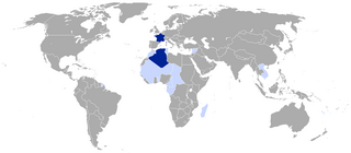
[This Map is badly colorized : Indochina (Annam, Tonkin, Cambodia, Laos), Pacific Islands, African countries, etc. are quite invisible.]

|
File:France 1939.svg
is a vector version of this file. It should be used in place of this PNG file when not inferior.
File:France 1939.png →
File:France 1939.svg
For more information, see
Help:SVG
.
|

|
Summary
| Description |
This map depicts the territorial situation of France subsequent to the 1939 en:Invasion of Poland .
|
||
| Date | |||
| Source |
|
||
| Author | VoodooIsland | ||
|
Permission
( Reusing this file ) |
|
Original upload log
The original description page was
here
. All following user names refer to en.wikipedia.
Upload date | User | Bytes | Dimensions | Comment
- 2011-09-09 00:38:29 | SpencerCS | 33545 | 1425×625 | Added French India
- 2010-04-29 10:55:54 | VoodooIsland | 58986 | 1425×625 | self-made