Europe_EU_laea_location_map.svg

Size of this PNG preview of this SVG file:
701 × 599 pixels
.
Other resolutions:
281 × 240 pixels
|
561 × 480 pixels
|
898 × 768 pixels
|
1,198 × 1,024 pixels
|
2,395 × 2,048 pixels
|
1,401 × 1,198 pixels
.
Summary
| Description |
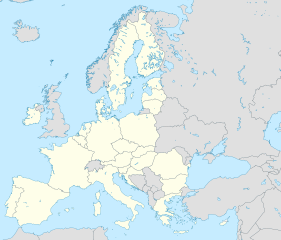
Deutsch:
Positionskarte
Europa
,
Europäische Union
; Politisch mit Staatsgrenzen; Flächentreue Azimutalprojektion
English:
Location map
Europe
,
European Union
; Political with state boundaries; Lambert azimuthal equal-area projection
Français :
Carte de localisation
Europe
,
Union européenne
; Politique avec frontières d'Etats; Projection azimuthale de Lambert
|
| Date | |
| Source |
Own work
|
| Author | Alexrk2 |
| Other versions |
[
]
|


.svg)


|
This map has been made or improved in the German
Kartenwerkstatt
(Map Lab)
. You can
propose maps
to improve as well.
|
Licensing
I, the copyright holder of this work, hereby publish it under the following license:
This file is licensed under the
Creative Commons
Attribution-Share Alike 3.0 Unported
license.
-
You are free:
- to share – to copy, distribute and transmit the work
- to remix – to adapt the work
-
Under the following conditions:
- attribution – You must give appropriate credit, provide a link to the license, and indicate if changes were made. You may do so in any reasonable manner, but not in any way that suggests the licensor endorses you or your use.
- share alike – If you remix, transform, or build upon the material, you must distribute your contributions under the same or compatible license as the original.